


Baguio is landslide prone area
3 MIN READ
By ARTHUR ALLAD-IW
www.nordis.net
FIRST OF TWO SERIES
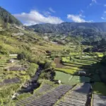
Sad to say, the city gov't has no comprehensive plans that would address the reality that larger areas of Baguio are prone to natural disaster like landslides. Photo by Aldwin Quitasol
BAGUIO CITY – Environmental experts say this summer capital of the country is a landslide prone area.
But intervention measures can be adopted by the local government to control damages that might be brought by this natural reality.
Sad to say, the city government has no comprehensive development plans that would address the reality that larger areas of the city are prone to natural disater like landslides.
Landslides prone area
The Mines and Geo-sciences Bureau of the Department of Environment and Natural Resources, as early as 2007, came up with the study and recommendations on the occurrences of landslides in this city and nearby Benguet.
The city is considered as a landslide prone terrain, according to Dr. Karlo L. Queano, Senior Science Research Specialist at the Land Geological Survey Division of the MGB.
It has all the ingredients being a prone area: a seismically active region, mountainous environment, degraded lands, areas subject to frequent periods of intense rainfall, and areas subject to rapid development.
Heavy rainfall and strong earthquake trigger landslides, said Queano, adding that factors contributing to landslides are steep slope, lack of vegetation, weakening of previously strong rocks by weathering, presence of relict structures like joint fractures, and overloading of scope surfaces by weight of rain, rock debris, dead trees, garbage dumps, buildings and houses and stock piles.
He classified the areas in the city as follows: high landslides susceptibility and critical area, high landslides susceptibility but not critical area, moderate landslide susceptibility area, and low landslide susceptibility area.
The first two classifications are characterized by high degree of mass movements, steep slopes and the high human initiated effects. Moderate landslides areas have slopes of 18 to 35 degrees while low susceptibility area has a gently slope of below 18 degrees.
In the MGB detailed city’s landslide hazard map, a bigger area of the city’s 49 square kilometer land area is characterized as high landslide susceptibility and critical area and high landslide susceptibility but not critical area. (Please see map)
The map also listed the following areas as susceptible to ground subsidence or sinkhole development: San Carlos Heights, Quezon Hill, San Roque Village, City Camp area, Dominican-Mirador, Area North of Bakakeng Central road, Suello Village, Dontogan area. The sinkhole areas are where lime stones are found, added a geologist from the MGB-CAR.
Concrete measures
When there is a higher degree of susceptibility to landslides (like the case in Baguio), there must also be a higher degree of intervention that must be done to regulate the effects of landslides, according to Engineer Faye Apil, head of the geology division office of the MGB-CAR.
The ideal would be to disallow the residents occupy these so called areas susceptible to landslides or resettlement should be in safer areas, she pointed out. Other mitigating measures can still be adopted. In 2008, their office conducted information and education campaign about the landslide issues in the city but only few had been interested so far.
Measures that could be adopted included drainage system must be ensured to catch run off water as the water can overflow and cause landslide, Apil said. Since most of the areas in the city are sloppy areas, competent posts must also be adopted to ensure that the resisting force (post) should be greater than the driving force.
Building of houses should be regulated and based on the characteristic of the location, Apil added. She noted that even in the high susceptibility to landslide areas, higher buildings were allowed which poses problem to the carrying capacity of the area.
Apil cited as example Cresencia Village, which is a gully area complimented by land filled soil.
Habitation of the area should have been disallowed in the past. Typhoon Pepeng claimed twenty three lives, mostly children, which could have been prevented had the government exercised it political will not to allow building houses in critical areas, like Cresencia Village. CONTINUED NEXT ISSUE# nordis.net